Obsidian Odyssey

Texas has abundant lithic resources, but obsidian is lacking from the list. That means that any obsidian found in an archaeological context within her present borders had to have been brought in from far away… but how, and by whom? Perhaps in ancient times by networks of itinerant traders or travelers who could cover vast distances?
SEEING THINGS IN A NEW (FLUORESCENT) LIGHT
A piece of obsidian can be analyzed with fluorescent technology that can pinpoint the spot where that specific volcanic glass outcrop occurs. Over the course of 53 years, the Texas Obsidian Project (TOP) has traced more than 300 prehistoric obsidian artifacts from Texas destinations to quarry sources in California, Idaho, Oregon, Wyoming, Arizona, Utah, and New Mexico, and much of Mexico, among others. The timeline of TOP data spans thousands of years from Paleolithic to Early Historic sites, suggesting obsidian has moved throughout Central and North America since time immemorial.
Even a small obsidian flake can be sourced, but a projectile point made from the material can also give it a time-diagnostic aspect. In a 2019 article in La Tierra, the Journal of the Southern Texas Archaeological Association, Hester, Glascock, Stewart, and Calame describe an Angostura point, believed to be around 8800 years old, that was found near Brownwood and sourced to Glass Buttes, Oregon ~1400 miles away. Further into antiquity, an obsidian Paleolithic point believed to be ~10,000 years old was found at Lubbock Lake, and an obsidian Clovis point was recovered at Blackwater Draw, both sourced from over 200 miles away at the Valles Caldera in New Mexico. And in the 1980s, a fluted obsidian Clovis point was found on a Port LaVaca beach; although source testing was inconclusive at the time of study, it had to have come from at least several hundred miles away. (Ref. A1)
On other continents, far obsidian trade has been shown to go back many thousands of years. The lengths that people went to in order to procure and then hold on to tools made from the exotic material attests to the immense value they placed on them as rare and prized possessions.

POLYNESIAN PUZZLE… OR PUT-ON?
In 2009, two hikers made international headlines when they went off-trail at Haleakala Crater on the island of Maui. Trevor Carter and Bryan Axtell stumbled on to a large, partially buried well-formed green obsidian stemmed triangular biface made in a projectile point shape. This was immediately noteworthy-- although Hawaiians have traded local obsidian since at least the 1400s, they were never known to use volcanic glass for spear or arrow points. On top of that, the only natural source of obsidian in Hawaii is localized to one outcrop in the Pu‘u Wa‘awa‘a formation on the Big Island—and it isn’t green, but black. (Ref. A2)
The “spear point” was examined in a lab: the source material came from the Sierra de Pachuca formation in Hidalgo, Mexico. This received much media attention and sparked a years-long debate across news articles and sensationalized TV shows asking “How did a spear point from Mexico end up on Maui, across the ocean over 3500 miles away?”
Assuming that Carter and Axtell were not staging a hoax--by most accounts there is general agreement that they were not-- opinions flew. Some argued this was definitive proof that prehistoric seafaring Polynesians had voyaged across the Pacific and made direct contact with Mesoamericans in ancient times and had returned to the island with the prized relic. “History books must be rewritten!” was their narrative.
On the other end of the debate, it was argued by some that their discovery was nothing more than a forgotten geocache (the popular GPS-based hobby enjoyed by millions whereby one player hides an object and gives clues for others to find it); others scoffed, attributing it to a Heineken beer bottle knapped by a visitor and perhaps forgotten on the trail after a few too many brewskis. Another theory suggests a hippie brought it to the mountain and left it during a new-age “harmonic convergence” event in 1987, or another such modern “offering” scenario. (Ref. A3) The Haleakala National Park is visited by up to a million or more people per year (almost 2 million in 1999) and guests often leave small shrine offerings within the interior rim of the crater. (Ref. A4) Others pointed out that the piece was crudely made and much larger than specimens from Mexican archaeological sites, and was notably similar to modern-made “arrowhead” momentos manufactured in Mexico and peddled at tourist souvenir stands near Mayan ruin sites. Pachuca obsidian is extensively mined in contemporary times, with souvenir trinkets being a major industry.
None of the scenarios are conclusive. Far from it. The piece was studied by actual scientists, not just TV show hosts, and was written up in more than one academic paper. What is not debated is that the obsidian that it was made from undoubtedly came from Hidalgo. WHEN it was manufactured and how it got to Haleakala is the fuel for the debate. Whatever the truth is, we might never know—Axtell claims the National Park Service seized the point from him in 2013 and it hasn’t been seen since.
Of course, the speculation and conjecture could not exist without a presumption of trust-- that the hikers were truthful and not staging a hoax. The same presumption should be in place for the following Long Distance Obsidian essay when considering provenience of the artifact. The “Fulton Beach Point” was certainly made from obsidian derived from a Casa Diablo outcrop in northeastern California. There is also solid affirmation of its style and age. The entire premise of its purported 1500-mile journey, however, is based on the word of the man who said he found it on the beach and subsequently sold it to the author nine years ago. His name has since been lost but at that time, nobody had performed diagnostic testing on the point so there is no reason to doubt he was telling the truth, but it can’t be definitively shown. It’s worth repeating here: Texas Cache Magazine publishes images and stories in good faith of contributors’ honesty and assurance of prehistoric authenticity and takes author Robert Bingham and the finder of the point at their word as to the veracity of the following “Long Distance Obsidian.” essay. By the way, if you are the beachcombing finder of it (a man with two sons who were teenagers in 2015 and sold the artifact at the Temple Artifact Show that year), or know who he is, please get in touch!
-R. Murray, Editor. 2024
LONG-DISTANCE OBSIDIAN

~Essay by R.B. Bingham
My first experience with what is commonly called ‘volcanic glass’ was visiting Obsidian Cliffs in Yellowstone Park in the family car when I was 8 years old. Glimpsed through the side window, even unpolished roadside fragments of black and red-streaked stone were reflecting the bright summer sunlight in a unique and amazing way. Better yet here was a solid 100-foot cliff of the stuff soaring up in crude hexagonal pillars to form the jagged edge of a massive volcanic plateau that covered nearly 5 square miles and was created by a single lava flow!
Many years later I would learn in freshman college geology that obsidian isn’t what we would normally call a ‘rock’ because it isn’t made up of minerals with a defining crystalline shape. Instead, it is more accurately classified as an amorphous solid (like window glass) which only occurs in high silica volcanic flows where the surface lava cooled too quickly for the viscous mass to form crystals. I also learned that freshly fractured obsidian is quite literally the sharpest edge of any material on Earth—in some cases actually holding a rigid edge one molecule across, 50 times sharper than surgical steel.
So obsidian became a preferred source material for the manufacture of cutting-edged stone tools by both Native Americans and many other ancient cultures worldwide. In addition, it is easily broken, thinned, and shaped in a controlled way using a stone-age technique called knapping. A process using both impact and pressure flaking techniques to make up a tool manufacturing tradition that began in Africa over 300,000 years ago and then later developed into a refined lithic technology that enabled early man to produce a wide range of sophisticated stone tools such as scrapers, knives, drills, and an ever-growing assortment of projectile points.
As fate would have it, in the summer of 2015 a gentleman with his two teenage sons approached me at the annual Artifact show in Temple, Texas and explained how he had recently found an obsidian point two weeks before while walking with his family along Fulton Beach on Copano Bay just north of Rockport. He handed it to me and asked what I would be willing to give him for it.
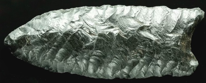
The tip and one ear of the three-inch projectile were slightly damaged by what had probably been a number of tumbling impacts from wave action but the flaking on both faces was immaculate and it certainly resembled the lanceolate shape of what I thought at the time might be an 11,000-year-old Paleolithic piece. I made him a reasonable offer for the unusual point which he gladly accepted and then I somewhat thoughtlessly filed it away amongst my other artifacts.
Five years later I was unexpectedly handed the email address of well-known and very highly respected Texas archeologist Dr. Tom Hester. Another avocational collector had become quickly convinced by a single photo that I had shown him of my Fulton Beach piece that the specimen’s intricate parallel-oblique flaking indicated that it was likely the only obsidian Saint Mary’s Hall type projectile point ever discovered in Texas, and boy, would Hester be excited to see it.
Indeed he was; because after forwarding a photo with a quick explanation of where the specimen had been found Hester immediately replied and requested I mail him the artifact so he could forward it to a lab at the University of Missouri for non-destructive XRF analysis to determine where it had been originally quarried. Since no tool-grade obsidian sources exist within the physical borders of Texas, this was of particular importance to archaeological research he had been conducting since 1970. After being repeatedly assured that it would be perfectly safe to transport it through the USPS I wrapped the Fulton Beach point in bubble-wrap, carefully packed it inside a small reinforced cardboard box, held my breath, and sent it off.
While waiting to hear back, I decided to do a little research to clarify what Hester meant by ‘XRF technology’, which is an acronym for X-Ray Fluorescence. It describes how a material sample responds when it is bombarded with a tightly focused X-Ray beam. Lower shell electrons are blasted out of orbit so higher energy electrons must drop down and replace them while releasing a burst of “fluorescent” (secondary X-ray) energy. The wavelength of this energy release depends on the distance between adjacent orbits, which provides a unique identifier for each of the trace elements being analyzed and the strength of this release indicates how much of each element is present in the radiated sample.
Since the 1960s, this simple, relatively inexpensive procedure has worked especially well and has been used by archaeologists worldwide to determine the compositional analysis of thousands of obsidian samples and trace them to their sources. This is only possible because high quality tool-grade obsidian is formed in one-time, uniquely distinctive volcanic deposits that lack most impurities and remain fairly homogenous throughout. This contrasts with deposits of other commonly utilized lithic materials like flint or chert which were instead formed over a much larger area, much longer periods of time, and often vary widely in trace element composition over just a short distance.
A little over a month later Hester sent a report from geochemist Dr. Michael Glascock at the University of Missouri who had carefully examined the Fulton Beach projectile point with a device formally described as a “ThermoScientific ARL Quantx energy-dispersive XRF spectrometer” and in a few minutes Dr. Glascock was able to accurately determine the concentrations of nine trace elements (iron, manganese, niobium, rubidium, strontium, thorium, yttrium, zinc, and zirconium) in parts per million. He then matched the specimen’s atomic ‘fingerprint’ with the data from hundreds of known obsidian sources in North America and determined that the find was originally quarried from the Casa-Diablo formation south of Mono Lake in northeastern California-- nearly 1,500 air-miles from where it was finally recovered near the Gulf of Mexico.

OFF TO MIZZOU:
From 2017-2018, the Fulton Beach Point went on another 1500-mile trip--this time from the author's home in South Austin to the University of Missouri in Columbia and back.


Above: Quantx benchtop ED-XRF Spectrometer with sample changer, and Obsidian specimens on spectrometer sample changer tray. Photos courtesy of of University of Missouri Archaeometry Lab.
The questions then became, “what type is it… and how old?” And ultimately, “How did it get here from so very far away?” The Fulton Beach point’s shape resembles some Texas Paleolithic styles; on the other hand, the piece lacks basal thinning or fluting and its overall thickness of about 7-8 mm probably excludes it from being classified as a St. Mary’s Hall point-- which has a thinner cross-section of about 4-6 mm. Furthermore, the oblique parallel flaking seems equally uncharacteristic of a Plainview point which in Texas usually exhibits random or collaterally parallel flaking patterns.
I then queried Dr. Hester about ancient obsidian points found in Texas, “Were they usually made here in a local style or made elsewhere and traded in?” He replied, “Perhaps both but overwhelmingly it was local Texas technology that was applied to obsidian flakes and trade blanks that were ‘imported’ into Texas as a raw material.” And he gave as two excellent examples “a Late Archaic [obsidian] corner-tang knife from a midden on the South San Gabriel near Liberty Hill sourced to Obsidian Ridge in the Jemez Mtns where no one ever made ‘tang knives’...and a fragmentary tang knife of Jemez (New Mexico) obsidian from Gaines County.” (Reference 1)
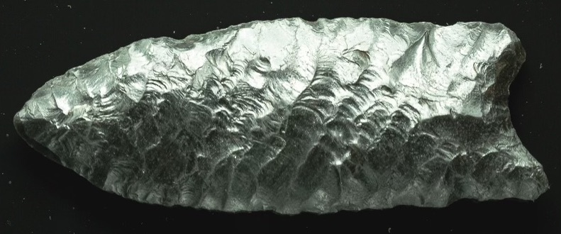
Hester kept the point for about a year and in a later text told me, “It was just 3-4 weeks ago that I finally found the right person, in California, Dr. Alan Philip Garfinkle, to identify the point. It is an Archaic point type named Humboldt Basal Notched. Their range extends from East/Southeast California all the way into the Great Basin... [Dr. Garfinkle] pointed out that the Casa Diablo source… is sort of linked to this Humboldt Basal notched point type, a middle archaic point ‘with beautiful parallel oblique flaking’.” (Reference 2)
The Humboldt type was named for its site location of “Lovelock Lake Bed Site, Humboldt Sink, Nevada” in 1968 by archaeologists Robert F. Heizer (who was Dr. Hester’s college mentor) and C. William Clewlow Jr. The basal notched type has since been characteristically described as: “Unshouldered and lanceolate bifaces with straight to slightly convex sides and lenticular in cross-sections. Bases exhibit parallel to moderately flared sides, and a deep basal notch or concavity, leaving two rounded as opposed to pointed ears. Workmanship is generally careful, most pieces showing extensive pressure retouch; examples of oblique parallel flaking are common.”(Reference 3)

Age data provided by repeated Carbon-14 dating and correlated hydration testing gathered at a number of Nevada and California archeological digs is a hot topic among archaeologists and has varied widely from 7000 yrs before present to AD 800. Dr. Garfinkle and Yohe II further suggested in their 2004 joint research paper that: “Contrary to previous conclusions, we believe that the [Basal Notched] biface forms had two distinct periods of use, an early (4000 to 500 B.C.) and a late (500 B.C. to A.D. 800) manifestation.” (Ref. B4)
In 1968 Heizer and Clewlow also discovered a wide-based variant of the Humboldt type which they named a “Triple T”, a further sub-category of the basal-notched family of points that our Fulton Beach piece also fits into because the Triple T is a wider lanceolate point with a concave base. Triple T points are similar to those found at the Fourth of July site near Denver, Colorado and the James Allen site near Laramie, Wyoming and appear to represent the oldest technology associated with the Humboldt point types (Thomas 1983; Thomas 1985). (Ref. B5)
Another diagnostic clincher for me is that the deep basal concavity of the Fulton Beach specimen clearly lacks invasive thinning or fluting of any kind on both sides and instead shares what appears to be another distinctive characteristic of a significant segment of Humboldt Basal-Notched points. They quite often lack reduction flake scars oriented towards the tip and instead exhibit a unique, “U-shaped base (that) was formed (exclusively) by steep-angle flaking.” (Ref. B5)


Above: The Fulton Beach Point (top) with three other Triple-T Humboldt notched points from the author’s collection.
In conclusion, I now believe that the Fulton Beach specimen was made in California after it was quarried at Casa Diablo and then transported to Texas by an individual explorer or group of individuals, or even as part of some wider migration or trade route that moved the point southeastward between 6000 and 1200 years ago. How or why, we can only guess… though we do know that ancient prehistoric exploration and subsequent trade routes commonly followed major waterways much like historical Indian trails and our present highway system. It seems likely that the Fulton Beach specimen could have arrived in Texas via the southern Gila River/Rio Grande and Pecos River connections or maybe via the more northern Humbolt River route which easily breaches the Continental Divide at its lowest point in southwestern Wyoming and then joins up with one of several south-eastward flowing drainage systems (such as the Platt, Arkansas, Red, Canadian and Brazos Rivers) as they wind their way toward the Gulf of Mexico. Then it somehow traveled along the Texas coast to finally end up near Rockport.
It was a dangerous and demanding long-distance undertaking for an intrepid few willing to cross the breadth of the North American Continent either on foot or by water without the help of a horse or primitive wheel, and for those few it must have not only been daring but the adventure of a lifetime.
-Robert B. Bingham is an avocational archaeologist who received his Bachelor’s Degree in Creative Writing in 1972 at the University of Montana. While earning his 3rd degree black belt he published several articles in Black Belt Magazine about Wing Chun Kung Fu. His previous article “Digging For Flint” appeared in Texas Cache Volume 22 #2 from 2018. He lives in Austin.

Above: The Long Valley Caldera contains three geologically distinct obsidian sources in the vicinity: Lookout Mountain, Sawmill Ridge, and Prospect Ridge (Ref. A5), one of which the Fulton Beach Point/TOP258 was manufactured from and subsequently taken across much of the continent to the Gulf of Mexico in ancient times.

Above: Shell midden on Copano Bay, near where the point was found in 2015. Photo by Texas Cache Editor.

Above: This close-up photo by Geoff Johnson shows the oblique parallel flaking of the Fulton Beach Point imposed over the Gulf waves that tumbled and polished it in the sand over the centuries. At Dr. Hester’s request, it was sent to the Archaeometry Laboratory at University of Missouri as part of the Texas Obsidian Project (TOP), and was assigned a research trinomial, TOP258.
Below: An obsidian outcrop in the Casa Diablo region in California from which TOP258 originated; Manmade prehistoric shell midden in Copano Bay, Texas close to where TOP258 was found by a beachcomber.


CASA DIABLO: A closer look at the quarry site of the Fulton Beach Point.
Casa Diablo, Spanish for “Devil’s House”, is an earthquake-prone landscape largely shaped by a series of catastrophic volcanic eruptions from over 700,000 years ago. It lies in a vast area of geologic elements like geysers, calderas, domes, hot springs, Mono Lake (an inland saline sea), and obsidian outcrops within view of Sierra Mountain Range peaks.


Traditionally, the area is the ancestral homeland of the Paiute (sometimes spelled Piute) with the Shoshone territory to their west and south. Due to the Fulton Beach Point’s diagnostic characteristics, however, its maker probably predated these cultures. The site was quarried for thousands of years by prehistoric tool makers, many of whom traveled great distances to and from the outcroppings.


Above: Indian children at Casa Diablo Hot Springs near the Paiute Trading Post, A Paiute Chief, names unknown to Texas Cache. Circa 1930s. Photos C/O Rich McCutcham Archives from owensvalleyhistory.com.

(Above) a pictograph and (below) a series of petroglyphs known as the Casa Diablo Circles. Photos from “Rock Art of the Owens Valley” by Bill Petry, 2019. Petry painstakingly authored this invaluable book about prehistoric art in the region with precise directions to get to them. View or download it at
https://www.academia.edu/46414304/Rock_Art_of_the_Owens_Valley

For more information about the Texas Obsidian Project, see
https://texasbeyondhistory.net/st-plains/prehistory/images/distant.html
SEE BOTTOM OF PAGE TO VIEW OR DOWNLOAD A FREE PDF VERSION OF THIS ARTICLE.
Citation:
This article has been copyrighted & published by Texas Cache Magazine. No part may be reproduced without attribution to the following citation: Bingham, Robert B. and Murray, Ryan. (2024). "Obsidian Odyssey" and "Long Distance Obsidian", Texas Cache Magazine, Volume 27 #2 Spring 2024, pp. 10-18; Photos of the artifact by Geoff Johnson unless indicated otherwise; https://texascachemagazine.com/obsidian-odyssey
No part of this article was generated by Artificial Intelligence.
References:
"Obsidian Odyssey" by Ryan Murray-
A1. Hester, T.R., M.D. Glascock, W. Stewart and D.L. Calame (2019). An obsidian Angostura point from Brown County, Texas, sourced to Glass Buttes, Oregon, with notes on other western obsidian sources. La Tierra 43: 73-78.
A2. Shea, Thomas. Geological Pamphlet, Dept. of Geology & Geophysics, University of Hawaii at Manoa. http://www.soest.hawaii.edu/GG/FACULTY/tshea/pdfs/pamphletPWW.pdf
A3. Boulanger, Matthew, “Mexican obsidian on Maui: Hawaiian connection, harmonic convergence, or hokum?” (2020). Anthropology Research. 9. https://scholar.smu.edu/hum_sci_anthropology_research/9
A4. National Park Service Official Visitation Numbers https://www.nationalparked.com/haleakala/visitation-statistics
A5. Northwest Research Obsidian Studies Laboratory, Corvallis, OR/obsidianlab.com
"Long-Distance Obsidian" by Robert B. Bingham-
Essay Author: Robert B. Bingham, photo of the grouping of Humboldt points c/o Bingham. Editing, arrangement, captions, map graphic, & Casa Diablo: A Closer Look page by Ryan Murray. Obsidian outcrop image in map used with permission from Molossian Institute of Volcanology; Fulton Beach Shell Midden photo by Murray.
B1. Personal communication with author and internal reference/Hester, T.R., Glascock, Michael D., and Cavanaugh, Weston, (2015-2016). Trace Element Analysis of an Obsidian Corner Tang Biface, Williamson County, Texas’. La Tierra, Volume 41.
B2. Dr. Garfinkle is a noted author and researcher of California stone tools.
B3. Bettinger, Robert L. (1978). Humboldt Basal-notched Bifaces as Time Markers in the Western Great Basin, pp.1-3.
B4. Garfinkel, Alan P., and Yohe II, Robert M. (2004). Antiquity and Function: Humboldt Basal-notched Bifaces in the Southwestern Great Basin. Journal of California and Great Basin Anthropology Vol. 24, No. 1, p.110.
B5. Des Planques, Scott A. (2001). Early and Middle Archaic Projectile Point Technologies in the Closed Basin Area of the San Luis Valley, Colorado. Master’s Thesis, University of Montana. pp.48-49